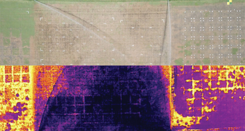
Drones can provide a wealth of information on golf courses, whether through the capture and analysis of true-color images (top) or pictures in the invisible spectrum (bottom). Photos by University of Arkansas System Division of Agriculture
More and more it seems we are hearing about drones on golf courses. The benefits, we are told, are many, from creating stunning aerial images of a golf course to saving costs on scouting the course and, ultimately, using water more efficiently.
In fact, one of the four research projects funded this year at universities around the country by GCSAA will make extensive use of drones as researchers compare wetting agent application strategies for efficacy and longevity in sand-based putting greens.
Leading the project will be Wendell Hutchens, Ph.D., at the University of Arkansas.
“This work will combine advanced statistical modeling techniques, remote sensing and in-ground soil moisture sensors to explore more efficient usage of water and reduced labor for hand-watering putting greens,” Hutchens says.
The project is funded by a Chapter Cooperative Research Grant through the GCSAA Foundation’s Dr. Michael Hurdzan Endowment and Mark Kizziar Research Endowment, with partial matching funds from the Mississippi Valley GCSA, the Ozark Turf Association,
GCSA of Arkansas and North Texas GCSA.
As superintendents await the results of such research, they also may be wondering how they can explore the possibility of using drones at their own golf courses. How to get started? Why not ask the experts?
Hutchens and doctoral horticulture student Daniel O’Brien, both with the university’s Agricultural Experiment Station, were happy to share their thoughts. Here are their top four tips on how to elevate your approach with the help of drones.
Define why you want to fly. Drones are capable of a lot of different things, and there are multiple ways to use the images and information they provide. Are you using it simply to take cool videos and pictures of your
property? Are you using it to map pests? Are you using it to predict wilt, pests or other disorders? Are you using it in conjunction with a GPS-guided sprayer for site-specific treatments? Are you using it to take photos of problem areas to highlight
in greens committee meetings? Being able to articulate what you want to get out of using a drone will go a long way to understanding the three most important aspects of getting started: what equipment to purchase; how you fly the drone (flight patterns);
and what you do with the images (or data).
Have realistic expectations. Drones can provide unique, powerful imagery, which can help inform decision-making, but they are still an evolving technology, with limitations. Practically speaking, this translates
into purchasing a less-expensive, small starter drone to get used to how it feels to operate the machinery. Most starter drones only fly manually and take true-color images and videos. They are great training tools to use when learning to fly drones.
As you’re learning, continue exploring what the more advanced options may offer, but with an appreciation that even the most expensive drone can’t tell you everything. Right now, it’s fair to say that drones can answer where something’s
going on, more so than telling you exactly what is going on. In other words, utilizing them as scouting tools rather than diagnostic tools is an excellent approach.
Appreciate the difference between taking pictures and taking measurements. Drone images can be captivating, which is why they are so popular. Then, add to that a multitude of numbers that
can be pulled out of an image — whether we’re talking about physical distances for building maps, or specialized reflectance for plant health indices — it’s easy to get excited. The key point is ensuring those numbers are accurate,
which doesn’t happen automatically. Again, if all you’re after are some striking photos/videos (which is a perfectly valid reason to fly a drone), it is a simple and straightforward process. But if you’re looking to really drill
down into the numbers, it’s important to understand some additional steps are needed along with the flying process (namely, equipment calibration and image processing).
Fly by the book. Study for and attain a Part 107 drone pilot’s license. This will ensure you are legal to fly under FAA regulations. There are excellent online study resources for the
Part 107 exam.
So, are drones right for your course? Give these tips some thought. We’ll have more specific thoughts from Hutchens and O’Brien in a future Turf column when they’ll talk more in-depth about the potential labor savings due to drones.
Darrell J. Pehr is GCM’s science editor.